River
Sasame Bridge: 1 Live Camera in Japan — Arakawa, 28.8 km
The bridge that carries Route 17 over the Arakawa. A transport ministry camera watches from the Toda side in Saitama, once a minute. It is the highest of the ten.
What you can see
Sasame Bridge carries the Shin-Omiya bypass of Route 17 over the Arakawa. The camera is on the Toda, Saitama side, and looks at a point 28.8 km from the river mouth.
Of the ten Arakawa cameras on this site, this is the furthest upstream. Below it the river runs straight and wide all the way to the sea as the Arakawa Floodway.
The right of the frame is wooded bank with stone revetment at the waterline. A bridge and transmission towers stand beyond it, the water is broad, and rowing shells cross it.
The images carry the name of the place burned into the bottom-left corner — for this one, Toda in Saitama. The operator is the Ministry of Land, Infrastructure and Transport's Lower Arakawa River Office.
The feed stops during works. If no picture comes up, leave it a while and open it again.
Cameras you can watch now: 1
All 1 are still images. Tap one to open it in the camera list.
-
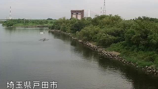 Sample August 2026
Sasame Bridge
Toda, Saitama · River
28.8 km from the river mouth. Where National Route 17 crosses the Arakawa, seen from the Toda side. From here down, the floodplain stays wide the whole way.
When to watch
It refreshes once a minute, among the shortest intervals on this site, so what you open is essentially now.
It earns its keep in heavy rain and typhoons. Being the furthest upstream of the ten, the water rises here before it rises downstream: once the flats start going under at this camera, the ones below will follow. Decide about evacuating on what your local government says. This camera is for seeing how things look.
On a calm day, morning and evening work best. The surface blows out white in the middle of the day, and low light carries further across to the far bank.
Winter air is clear enough to sharpen the bridge and the towers behind it. Nothing shows after dark.
If it isn't showing
To follow the same river with ten cameras from upstream to the sea, The Arakawa — from this bridge down to Shinsuna in Koto-ku, where it reaches the sea.
For the mouth of the floodway on its own, Iwabuchi Floodgate. Cameras on bridges and cameras pointed at them are gathered in Bridges, and the prefecture page is Saitama.
Every river camera on the site, in Japan and abroad, is in River, and reading a river in flood is written up in Why river cameras exist.
Where to find Sasame Bridge
Agencies publishing the cameras on this page
- MLIT Arakawa Downstream River Office (PDL 1.0) — Official site
The footage belongs to each agency. This site is an unofficial guide, and each sample frame was copied once per camera under that agency's terms of use.