Live camera
Surtsey, looking northeast live camera
An island born from undersea eruptions between 1963 and 1967. It has been kept closed to people so that the way life settles on bare lava could be watched from the start, and it became a World Heritage site in 2008. Only researchers with permission may land. The picture here updates once an hour, and some days none arrives.
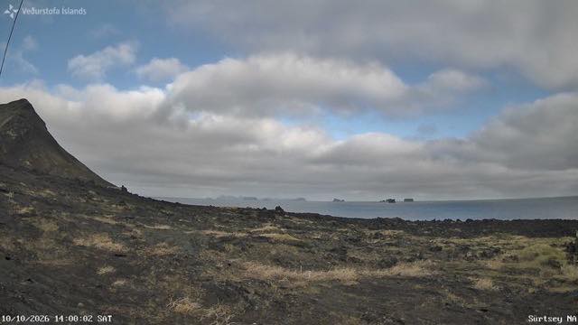 Sample October 2026
What you are looking at
Black lava and dead-coloured grass fill the foreground, and on the left the slope of a crater cone rises. Beyond it is the sea, with a few small rocky shapes strung along the horizon. Sky takes up close to half the frame.
Surtsey sits at the south-western end of Vestmannaeyjar, and it came up out of the sea in an undersea eruption that began on 14 November 1963. The eruption ran until 5 June 1967. The name is taken from Surtr, the fire giant of Norse myth. The camera faces north-east; the shapes along the horizon are other islands of the same group, and beyond them is the south coast of mainland Iceland, a little over thirty kilometres away.
When the eruption stopped the island measured 2.65 square kilometres. The sea has been cutting it back ever since, and by 2012 it was down to about 1.3 square kilometres. What goes is the consolidated ash; the parts capped by lava are harder, and those are expected to last longest.
People have been kept off since the island was born, so that the arrival of living things on bare ground could be recorded from the beginning. The first plant was found in 1965. When gulls began nesting in 1986 their droppings fed the soil and grassland spread. It became a World Heritage site in 2008, and only researchers with a permit may land.
A still image, one an hour, and there are hours when none arrives. Nine hours behind Japan, with no summer time.
About this camera
| Place | Vestmannaeyjar, off the south coast |
| Format | Still, every 10 min |
| Time zone | Atlantic/Reykjavik (UTC+0) |
| Category | Volcano · World Heritage · Sea |
| Operator | Icelandic Meteorological Office |
| Terms of use | Free to use with credit |
The operator's own page
The footage belongs to each agency. This site is an unofficial guide, and each sample frame was copied once per camera under that agency's terms of use.
Cameras nearby
- Reykjavík, looking northReykjavíkStill, every 10 min
- HveravellirCentral HighlandsStill, every 10 min
- Höfn, looking northHornafjörður, southeastStill, every 10 min
- Lake Mývatn, looking southeastMývatn, northeastStill, every 10 min
- Mánárbakki, looking northeastTjörnes peninsula, northeastStill, every 10 min